Warsaw Real Estate Development Opportunity Map
GOAL
RESULT
PROJECT DURATION
Build a reproducible GIS screening model to identify and rank high-opportunity real estate development candidate zones in Warsaw.
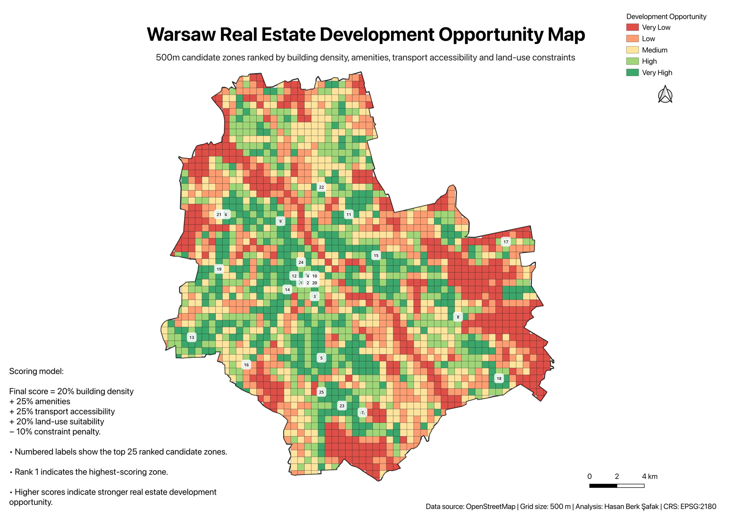
Created a final QGIS opportunity map with 2,117 scored candidate zones and the top 25 ranked zones highlighted for further review.
This end-to-end portfolio project was completed in June 2026.
A similar GIS screening project would typically take 3 to 7 days, depending on data availability, spatial data quality, and the level of validation required.
- 2,117 Candidate Zones
- 500m Grid
- Top 25 Ranked Zones
- OpenStreetMap Data
- EPSG:2180 CRS
This project transforms open geospatial data into a reproducible GIS screening model for identifying high-opportunity real estate development candidate zones in Warsaw.
Project Overview
This project is a reproducible GIS screening workflow designed to identify and rank high-opportunity real estate development candidate zones in Warsaw.
The model combines OpenStreetMap-based spatial data, a 500m candidate grid, multiple location-based metrics, and a weighted scoring model to support early-stage site selection analysis. The final output is a QGIS opportunity map showing development potential across the city and highlighting the top 25 ranked candidate zones for further review.
Business Question
Where are the strongest candidate zones for real estate development screening in Warsaw?
Real estate site selection often begins with a large urban search area and many competing location factors. The goal of this project was to narrow Warsaw into a smaller set of priority zones that can be reviewed later with parcel-level, zoning, legal, and market data.
Approach
I built a Python-based GIS workflow that extracts and processes OpenStreetMap data, standardizes spatial layers to EPSG:2180, generates a 500m candidate grid, and calculates spatial indicators for each grid cell.
The model evaluates each candidate zone using building density, amenity attractiveness, transport accessibility, land-use suitability, and constraint indicators. These metrics are then combined into a final weighted opportunity score.
The workflow is designed to be transparent and repeatable, making it easier to explain how each candidate zone was scored and why certain areas were prioritized.
Methodology
The analysis followed a staged spatial workflow:
- Raw OpenStreetMap data extraction for Warsaw
- Data cleaning and CRS standardization
- 500m candidate grid generation
- Building density metric calculation
- Amenity and commercial attractiveness scoring
- Transport accessibility scoring
- Land-use suitability and constraint scoring
- Final weighted opportunity scoring
- Top 25 ranked candidate zone selection
- Final QGIS map layout and export
Scoring Model
Final score =
20% building density
- 25% amenities
- 25% transport accessibility
- 20% land-use suitability
− 10% constraint penalty
Higher scores indicate stronger screening potential based on the selected spatial indicators. The score is designed for early-stage prioritization, not final investment decision-making.
Final Output
The final output is a QGIS map highlighting development opportunity classes across Warsaw and labeling the top 25 ranked candidate zones.
The project also includes supporting GeoJSON outputs, CSV summary tables, a PDF map export, and a reproducible Python workflow. These outputs allow the analysis to be reviewed both visually and technically.
Key Deliverables
Final opportunity map
Ranked top 25 candidate zones
Scored GeoJSON output
CSV summary tables
QGIS project file
Reproducible Python workflow
Portfolio-ready GitHub repository
Business Value
This project demonstrates how GIS can support early-stage real estate site screening by turning open geospatial data into a structured ranking framework.
The model helps focus deeper due diligence on a smaller set of candidate areas and makes the screening logic transparent, repeatable, and easier to communicate to stakeholders. A similar workflow could support real estate research, site selection, urban analysis, market screening, and location intelligence projects.
Limitations
This is a screening-level GIS model, not a final investment recommendation.
It does not include parcel ownership, zoning permissions, land prices, transaction data, demographics, flood risk, noise risk, or detailed legal constraints. Any real-world development decision would require additional parcel-level validation, planning review, market analysis, and professional due diligence.
Tools Used
Python
GeoPandas
Shapely
Pandas
QGIS
OpenStreetMap
Git
GitHub
What I Would Improve Next
The next version of this project could integrate parcel-level cadastral data, zoning and planning constraints, market price indicators, demographic variables, flood and noise risk layers, and an interactive web dashboard for reviewing candidate zones.
Buttons
View GitHub Repository
https://github.com/hberksafak/real-estate-location-intelligence-warsaw
Download Final Map PDF
https://github.com/hberksafak/real-estate-location-intelligence-warsaw/blob/main/outputs/report/final_opportunity_map_top25.pdf
Short closing line
This project shows how open geospatial data and reproducible GIS workflows can turn a broad urban area into a focused set of candidate zones for further real estate development analysis.